
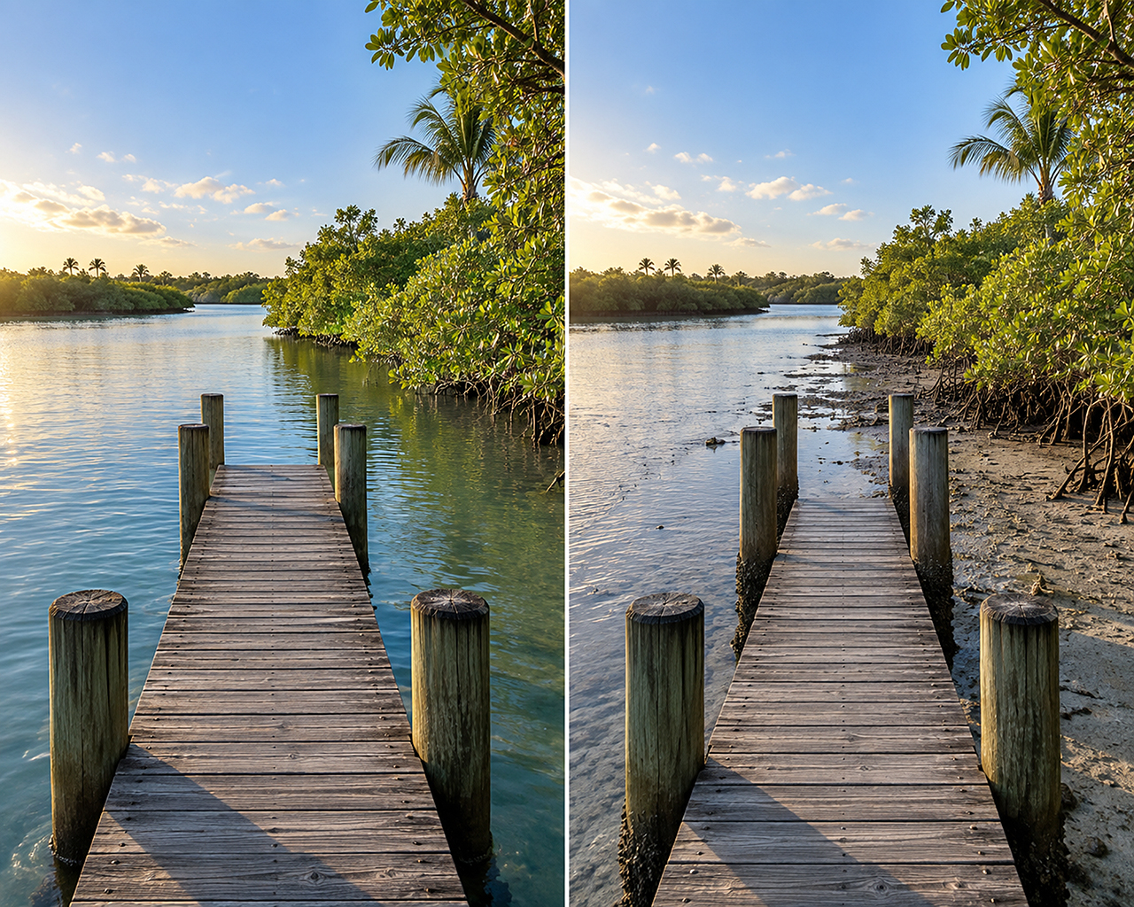
Southwest Florida offers some of the most memorable boating in the state. From Tampa Bay and Sarasota to Pine Island Sound, Marco Island and the Ten Thousand Islands, boaters can explore mangrove shorelines, sandy passes, grass flats, and protected bays.

These waters can also become remarkably shallow. A route that looks wide open at high tide may expose an oyster bar or seagrass bed just a few hours later. Understanding the tide is therefore essential; not only for protecting your boat, but also for keeping passengers safe and preserving Florida’s marine environment.
How tides work in Southwest Florida
Tides are primarily caused by the gravitational pull of the moon and sun. As the water rises, the tide is described as “flooding” or “coming in.” After high tide, the water begins to fall or “ebb” until it reaches low tide.
Southwest Florida does not follow one perfectly uniform daily pattern. Depending on the date and location, boaters may see two high tides and two low tides of different heights, or a pattern dominated by one especially high and one especially low tide.
The size of the tidal change also varies considerably across the region. NOAA’s long-term station information shows a mean tidal range of approximately two feet on the outer coast at Naples, while the mean range at Fort Myers, farther up the Caloosahatchee River, is less than one foot. That does not mean the river is always predictable or that its water level changes are insignificant. It demonstrates why boaters should use a tide station near their actual destination rather than relying on a prediction from another part of the coast.
Use the closest tide station
A tide prediction for Naples Beach is not necessarily an accurate prediction for Naples Bay, Marco Island, Estero Bay, Matlacha Pass or the upper Caloosahatchee River. High and low tides occur at different times as water moves through passes, bays, canals and rivers.
Before leaving the dock, visit NOAA Tides and Currents and select the station closest to your route. Southwest Florida stations include locations around:
- Everglades City and Chokoloskee
- Marco Island and Caxambas Pass
- Naples and Naples Bay
- Wiggins Pass
- Estero Bay and Matanzas Pass
- San Carlos Bay
- Sanibel and Captiva
- Pine Island Sound and Matlacha Pass
- Bokeelia and Charlotte Harbor
- Fort Myers and the Caloosahatchee River
Check both the time and predicted height of each tide. Two low tides on the same day may not be equally low, and that difference can determine whether a shallow route is passable.
A tide prediction is not a guarantee
A tide table predicts the astronomical tide—the portion of the water-level change produced by the moon and sun. It cannot perfectly account for wind, atmospheric pressure, heavy rain, freshwater runoff or storms.
NOAA cautions that short-term weather can cause observed water levels to differ from predictions, especially inside rivers, bays and estuaries. This is particularly important in Southwest Florida, where sustained wind can push water into or out of shallow coastal systems.
Strong onshore winds can elevate water levels. Persistent offshore or northerly winds can pull water away from the coast and create a lower-than-predicted tide. Heavy rainfall and river discharge can also affect water levels and currents.
Whenever possible, compare the predicted tide with NOAA’s observed water level at an active monitoring station. Also review the marine forecast before departure. During tropical weather, cold fronts or other strong weather systems, do not treat an ordinary tide table as a complete picture of conditions.
Low tide deserves extra planning
Low tide presents some of Southwest Florida’s most common boating hazards:
- Shallow grass flats may become impassable.
- Oyster bars and sandbars can sit just below the surface.
- Canal entrances and residential docks may lose usable depth.
- Familiar shortcuts may no longer provide enough clearance.
- The ramp or lift used at departure may be difficult to use upon return.
- Markers can appear to show deep water even when the surrounding channel has shifted or shoaled.
Know your boat’s draft, including the additional clearance required by the engine or running gear. Allow a safety margin rather than planning to use every inch of predicted water. When entering an unfamiliar marina, restaurant, canal or anchorage, ask about the controlling depth and whether access is limited at low tide. Local knowledge is valuable, but it should supplement—not replace—current charts, markers, depth readings and tide information.
Moving water creates additional risks
The difference between high and low tide is only part of the story. Boaters must also consider tidal current.
Water accelerates as it moves through narrow passes, bridge openings, inlets and constricted channels. Current can affect steering, docking, anchoring and the amount of distance required to stop or turn. At some passes, opposing wind and current can also produce steep, closely spaced waves.
Approach crowded passes and bridges cautiously. Keep adequate distance from other vessels, anticipate sideways set and avoid drifting broadside to the current. When docking, determine whether wind or current has the stronger influence before committing to the approach.
Near “slack water,” the current may briefly weaken as its direction changes. However, slack current does not always occur at the exact published time of high or low tide, particularly away from the reference station.
Protect seagrass and your boat
Southwest Florida’s shallow seagrass meadows support fish, manatees, sea turtles and many other species. They are also easily damaged by propellers and vessel groundings.
The Florida Fish and Wildlife Conservation Commission recommends consulting tide and navigation charts, remaining in marked channels when unfamiliar with an area and avoiding shortcuts across grass flats. Navigation charts may identify seagrass with light-green shading or the abbreviation “grs.”
If the water begins to shallow:
- Slow down before the boat touches bottom.
- Watch the depth sounder and look for changes in water color or bottom texture.
- Trim the motor only when it can be done without damaging the bottom.
- Turn around while sufficient depth remains.
- Do not accelerate across vegetation in an attempt to force the boat through.
If you run aground, stop the engine. Do not power off, because the propeller can dig a deeper hole, damage the lower unit and leave a long-lasting scar through the seagrass. Check for injuries and damage, then use an anchor, push pole or other appropriate method to move toward deeper water when it is safe to do so. For a serious grounding, request professional assistance.
FWC notes that propeller scars can take years to recover and that damaging seagrass is prohibited in certain state waters. Responsible shallow-water operation protects both the habitat and the boating experience.
Plan the return trip, not just the departure
One of the easiest tidal mistakes is leaving on favorable water without checking what conditions will be like later.
A falling tide can strand a boat at a beach, sandbar, fishing flat or shallow dock. Before stopping, consider:
- Is the tide rising or falling?
- How much lower will it become?
- Does the route back cross a shallow area?
- Will the ramp, canal or lift still have sufficient water?
- Could wind make the water level lower than predicted?
- Is there a safe alternative route?
When anchoring near a beach or sandbar, monitor the boat’s position and depth. As the water falls, move the boat before it settles onto the bottom. When the tide is rising, allow for changing swing room and make sure the anchor remains secure.
High tides bring their own concerns
High water can improve access to shallow areas, but it does not eliminate risk. A high tide may cover hazards that are normally visible, including oyster bars, rocks, pilings, seawalls and flooded vegetation. Clearance beneath fixed bridges can also decrease as the water rises.
Unusually high astronomical tides—sometimes called king tides—may contribute to localized flooding, especially when combined with onshore wind, heavy rain or a storm system. Check actual water levels and weather alerts when elevated tides are expected. Storm surge should never be treated as an ordinary high tide. It is a dangerous weather-driven rise in water that may occur with tropical systems and other severe storms. Follow official evacuation and marine safety guidance rather than attempting to calculate safe conditions from a tide table.
A practical pre-departure checklist
Before boating in Southwest Florida tidal waters:
- Check the tide at the station nearest your route.
- Review both the predicted times and heights.
- Compare predictions with observed water levels when available.
- Check the marine weather forecast, wind direction and recent rainfall.
- Know your boat’s draft and maintain a clearance margin.
- Review current charts and local notices.
- Plan for conditions at the time of your return.
- Stay within marked channels when unfamiliar with an area.
- Avoid running across seagrass, oyster beds and shallow flats.
- Reduce speed in passes, near bridges and anywhere current is strong.
Carry required safety equipment and a reliable means of communication.
Respect the water, and enjoy the coast
Southwest Florida tides are not something boaters need to fear, but they must be respected. The most capable local boaters combine tide predictions, weather information, charts, observations and conservative judgment.
A few minutes of planning can prevent a grounding, a damaged propeller or an unexpectedly difficult trip home. More importantly, responsible tide-aware boating protects passengers and preserves the mangrove shorelines and seagrass meadows that make Southwest Florida such an extraordinary place to be on the water.
For trip planning, consult NOAA Tides and Currents, the National Weather Service marine forecast, the Florida Fish and Wildlife Conservation Commission’s boating information, and Weather and Tides.
This article provides general educational information. Local conditions can change rapidly, and tide predictions should not be used as the sole basis for navigation.