If dry conditions continue, several locks will be closed for safety reasons.
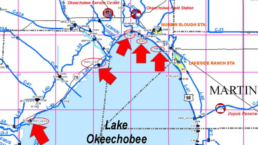
This map shows the locks that could be closed because of low water levels in Lake Okeechobee. Click on image to see a larger version.
West Palm Beach, FL – Boaters navigating to and from Lake Okeechobee, please be advised that if drier-than-average conditions persist and the levels of Lake Okeechobee are further reduced, the South Florida Water Management District (SFWMD) will close navigation locks on the north shore for safety reasons. Personal injury and lock damage could occur when boats pass through these structures at water levels below any of the designated safety limits.
Today, the water level in Lake Okeechobee is 12.77 feet. However, if the lake falls below 12 feet, locks along the north shore will be closed. The locks potentially affected are:
• Martin County: S-135 structure, J&S Fish Camp
• Okeechobee County: G-36 structure, Henry Creek
• Glades County: S-127 structure, Buckhead Ridge
• Glades County: S-131 structure, Lakeport
• ***Okeechobee County: S-193 structure, Taylor Creek, will close if lake levels fall below 11 feet.***
Despite these other possible closures, the S-310 lock on the south shore at Clewiston in Hendry County will remain open even as low lake levels continue. The U.S. Army Corps of Engineers manages the locks leading from the lake to the St. Lucie and Caloosahatchee rivers.
To get the latest information on Lake Okeechobee’s water volume, including daily levels, visit SFWMD’s website at www.sfwmd.gov/science-data/levels.
To get the latest information on navigation through SFWMD structures and waterways, visit www.sfwmd.gov/navigation.